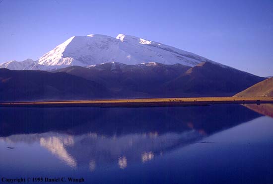
Kashgar-Atush
Uyghur Photo Site | Site Manager | Contact Page | Information | In the World | Kashgar-Atush | Turpan | Urumchi-Qaramay | Qumul-Korla | Hoten-Aksu | Ili-Altay | Kucha | People | Culture | Nature | Favorite Links | Uyghur Photo Guest Book
Some information about Kashgar and Atush


Welcome to Kashgar  !!!

Kashgar is oasis city in the Uyghur Region of . Kashgar lies at the far western end of the Tarim Basin, in a fertile oasis of loess (silt deposited by the wind) and alluvial soils watered by the Kashgar River and by a series of wells. The climate of the area is extremely arid, with variable rainfall averaging about 4 in. (100 mm) a year; most of the rain falls during the hot summer months. Average temperatures range from 21?F (-6?C) in January to 79?F (26?C) in July.
Kashgar's historical importance has been primarily as a trading centre. Situated at the foot of the Pamirs (mountains), where the ranges of the Tengri tagh and the Qara Qorum Mountains join, Kashgar commanded historic caravan routes to the Fergana Valley in Uzbekistan (west), to Jammu and Kashmir (south), and to Urumchi and the Ili River valley (north).
The oasis is very fertile, growing wheat, corn (maize), barley, rice, beans, and a great deal of cotton. The oasis also produces fruit and is known for its melons, grapes, peaches, apricots, and cherries. There is some fishing in the rivers of the oasis. The oasis peoples engage in a variety of handicrafts; both cotton and silk textiles are produced, together with felts, rugs, furs, leatherware, and pottery. Some copper is produced in the area, which also ships wool, hides, and a variety of animal products to other parts of Uyghur Region . Pop. (1989 est.) 168,900.

Kashgar is located in the southwestern part of Uyghur Region, and has a history of more than 2000 years. Owing to its favorable position, countless merchants from many parts of the world went to there to make a living. So Kashgar became more and more important, and is called as "the pearl on the Old Silk Road". Kashgar city is divided into two parts: the new district and the old district.
The history of Kashgar is dominated by its strategic position, first as a critical junction on the Silk Road, and more recently as the meeting point of three empires - Chinese, Soviet and British. Both Britain and the Soviet Union maintained consulates in Kashgar until 1949: the British with an eye to their interests across the frontier in India, the Soviets (so everyone assumed) with the long-term intention of absorbing Uyghur Region into their Central Asian orbit. The conspiracies of this period are brilliantly evoked in Peter Fleming's News from Tartary and Ella Maillart's Forbidden Journey. At the time of Fleming's visit, in 1935, the city was in effect run by the Soviets, who had brought their rail line to within two days of Kashgar

Location: located between 73?0?- 70?7?east longitude and 35?0?- 40?8?north latitude, bordering the Taklamakan desert in the east, the Qara qorum Range and Ali prefecture of in the south
Physical Features: two river systems of the Yarkant River and the Kashgar River with a total annual runoff of 10.9 to 11.9 billion cubic meters
Area: 162.000 sq km

Climatic Features: mainly a continental climate; varied greatly with topography as plain climate, desert climate and mountain climate; frost-free period of 215 days
Average Temperature: 11.7
annually with the lowest of -24.4
Rainfall: 27 mm annually
Mountains: Mt. Kongur
Rivers: Yarhant River, Kashgar River
Products: wheat, maize cotton, barley, highland barley, rape, sesame, peanuts and flax
Local Highlights: kashgar's local songs and dance ,crafts, roast lamb, shishi-kebab, and baled fish


Welcome to Atush  !!!


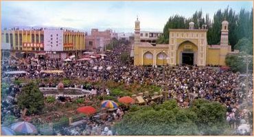
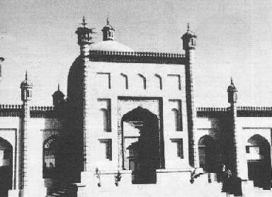
Heytgah Mosque
Built in 1442, the Heytgah Mosque is the main historic sight in Kashgar and dominates the central square. It is one of the largest and most active mosques in the country and attracts close to 10,000 worshippers every Friday afternoon and almost double that number during religious festivals. The mosque exemplifies grand Islamic architecture, with a rectangular entranceway, flanked by intricately designed, slender minarets. The face of the mosque is filled with yellow and white tiling, interspersed with designs in blues and greens. Inside the mosque there are charming courtyards and gardens where worshippers assemble before entering the halls
Mahmut From Kashgar-- Linguist of the 11 century


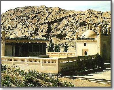
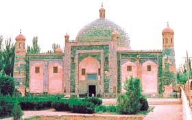
The Tomb Of Appaq Hoja
The Apaq Hoja Tomb, five miles northeast of Kashgar(is an important cultural unit protected by the Uyghur Region. As a tomb of the descendants of an Islamic sage, it was built around 1640. The legend has it that seventy-two persons in all of five generations of the same family were buried in the tomb. The first generation buried here was Yusuf Hoja, a celebrated Islam missionary. After he died, his eldest son Apak Hoja carried on the missionary work and became the leader of the famous White Cap Sect during the seventeenth century and seized the power of the Yarkent Kingdom for a time. Apaq Hoja was buried in 1693 and was buried in the tomb. His reputation was greater than his father's, so the tomb was renamed "The Apaq Hoja Tomb."

The tomb is a group of beautiful and magnificent buildings including the Tombs Hall, the Doctrine-Teaching Hall, the Great Hall of Prayer, the gate tower, a pond and an orchard. The Tombs Hall, with a dome-shaped top of seventeen meters in diameter and covered with green glazed tiles outside, is twenty-six meters high and thirty-nine meters long at the base. the hall is high, spacious and columnless. Inside the hall, there is a high terrace on which the tombs are arranged. All the tombs are built of glazed bricks with very beautiful patterns of blue flowers on a white background, glittering, simple and elegant. The Lesser Hall of Prayer and the gate tower are outmost buildings decorated with colorful paintings and elegant brick carvings. Outside the tomb there is a crystal-clear pond lined by tall trees making the place pleasantly quiet and beautiful.


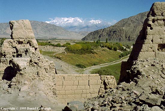
The Tashkorghan Fort
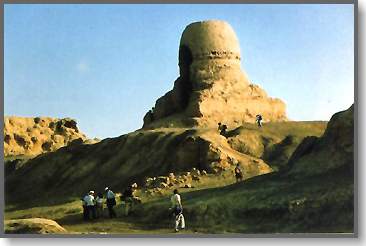
The Mortom Buddist Site